Fhs/fs/7/Appleyard.html
[[Fhs/fs/7/index.html|File:Freotopia fhs fs .. .. img banner.jpg]]
Fremantle Stuff > FHS > Fremantle Studies > 7 > Appleyard
Port plans: Stirling to O’Connor
Reg Appleyard, AM
Appleyard, Reg 2012, 'Port plans: Stirling to O'Connor', Fremantle Studies, 7: 123-136.
Fremantle is a port that waited. Waited for one hundred and thirty two years after its discovery in 1696 by the Dutch explorer Willem de Vlamingh before it was settled by the British. Waited another seventy years before settlers could raise sufficient funds to remove a rocky bar across the entrance to Swan River and develop an inner harbour. And waited another sixty-five years before its potential was realised with the dredging of a channel into capacious Cockburn Sound.
Pre-settlement maritime explorers such as Vlamingh experienced great difficulty in crossing the rock and sand bar that blocked entry to Swan River. Members of the 1801 Baudin (French) expedition made three attempts before getting through. [1] A sketch by Colas, a member of that expedition, shows that their passage into the river was on the starboard (right hand) side (Figure 1). The party spent much time and effort pushing their boat across the bar and across mud flats further up river. Louis de Freycinet, a sub-lieutenant with the Baudin expedition, wrote that because Swan River was difficult to enter it would not be a proper place to provide fresh water which was available only at a great distance up river. [2]

Figure 1 Entrance at Swan River. A sketch by Colas, pharmacist with the Baudin expedition, 1801 (Leslie Marchant)
The western third of the Australian continent remained unclaimed until 1828. James Stirling was sent to Swan River in 1827 essentially to ascertain whether the surrounding area had sufficient good soil to grow crops for settlers, and also whether the coast had safe anchorages. In his Report to Governor Darling (NSW), [3] Stirling argued that while Gage Roads would be both safe and convenient as an anchorage, he predicted that, in time, the river itself would become the main anchorage for merchant vessels, and Cockburn Sound an excellent anchorage for ships of war. The bar across the river’s mouth, he wrote, could be removed “without difficulty or great expense”, thus allowing merchant vessels to sail only one or two kilometers to natural cliffs or wharfs with four, five or six fathoms of water close to their sides (Rocky Bay). A few kilometers further on (Freshwater Bay), there was a large expanse of water which, if it had an entrance (ie, removal of the bar at river’s mouth) would become “the finest harbour in the world”.
On his return to Sydney, Stirling stopped at King George Sound to pick up Edmund Lockyer who had been sent there to confirm British interest in the continent’s unclaimed western third. Lockyer had been greatly impressed by the land-locked Sound and argued that its potential lay in the seal and whale trade. Governor Darling, to whom both Stirling and Lockyer reported, clearly supported Swan River as the base for a British settlement. However, while his letter to the Colonial Office referred to Swan River’s commodious and magnificent basin, it also regretted that the bar prevented easy entry to that river. 4
 Stirling returned to Swan River in 1829 as Lieutenant Governor. Although his 1827 proposal that the bar across the river mouth could be removed without difficulty or great expense was achieved neither by Stirling nor any governor that followed him during the next seventy years, an array of plans, some relating to the bar’s removal, and others to the creation of moles and wharves outside the river, were considered during that period. Indeed, within a few months of his return to Swan River, Stirling reconsidered the cost and difficulties of opening the bar and proposed that a more appropriate entry to the river would be by a channel from the sea to Rocky Bay. (Figure 2).
Meantime, the first ‘jetty' to receive cargo was built by Daniel Scott at Bathers Bay. Shown in Morrell’s painting (Plate 1) and enlarged in Plate 2, it served as the colony’s only wharf until the Fremantle Whaling Company erected a stone jetty in 1837 on the southern side of Arthur Head connected by a tunnel under the Head itself.
Some Fremantle merchants opposed removal of the bar on grounds that vessels would sail up-river to the capital, and to safe anchorages by cliffs along the river, thereby causing the demise of Fremantle as a port.

Plate 1 Richard Morrell's painting of Fremantle from Church Hill east of the town, 1832 (National Library of Australia)

Plate 2 Detail of Richard Morrell’s painting of Fremantle showing jetty built by Daniel Scott, 1832 (National Library of Australia)
And in 1850 an attempt to open the bar came to nought when blasting fuses failed to arrive from London. But probably of greater significance was that in the early 1850s Fremantle was struck off the list of ports for P&O’s new steamships. [5] King George Sound became the company’s port of call, a decision clearly influenced by the arrival of Chusan on a dry-run to test facilities at each potential coaling station. She arrived at Fremantle during an equinoxial gale and her master was so alarmed that at the first propitious moment he sailed away. His report to London owners was so critical of Fremantle port that without further ado it was struck off ports of call on the Australia run. [6]
 Suggestions for improvement of Fremantle port from 1850 to 1870 were many, and frequent. [7] Clearing a passage through the bar remained the main objective. In 1856 Captain Wray proposed a channel 60ft wide and 6ft deep. Settlers were clearly interested: forty eight offering £5 each towards the estimated cost. Others were prepared to contribute £5 for every additional foot depth of channel. During the same year, William Phelps suggested that the river entrance be developed into a 300ft wide channel by reclaiming the shallow banks (Figure 3).
The period 1870 to 1890 can be readily identified as the “period of plans”. In 1869, Governor Weld wrote to Mr Doyne, an engineer in Melbourne, asking him to come to the colony and advise on the construction of harbour and river works. Accompanied by George Chamier, who described Fremantle as a “queer looking place, not young and growing like most colonial towns, but old and withered crumbling away into its native sand”, Doyne suggested that there was no case for the construction of an artificial harbour outside the river because it, and vessels alongside, would be damaged by pervading strong winds.  He suggested that two breakwaters could solve the many problems and was, therefore, the first to foreshadow the design finally adopted. But he was also realistic enough to see that the cost of such a project would be ‘prohibitive’ for the small colony.
Among the many plans proposed after 1870 was the imaginative one by Edward Troode (Figure 4). A floating breakwater anchored off the river entrance would protect the northern side of an open-piled jetty extending south west from Arthur Head. This, he claimed, would provide smooth water for vessels loading/unloading at the jetty. The whole operation, done by convict labour, would cost £5000.
 Troode’s plan led many others to offer their ‘solutions’. In 1872, G. Randell proposed one not dissimilar to the plan finally adopted - a breakwater from Rous Head (SW direction) and a smaller breakwater from Arthur Head, and partial reclamation of the inner harbour. He estimated that it would cost £14,754 if done by convict labour (Figure 5).
 In 1874 Nicolay revived the Rocky Bay development that had been suggested by Stirling in 1830. A channel 24’ deep and 60’ wide with breakwaters on both sides would allow vessels to sail through a “mile of deep water” (Figure 6). Vessels of up to 18’ draft would also sail from Rocky Bay to Fremantle where a floating bridge would be constructed. However, the plan would cost £100,000 which did not impress a Select Committee that had been established to evaluate this and other plans. The Committee recommended that development should be centred on Gage Roads.
The colony was too lacking in resources, both human and monetary, to carry through these proposals. Plans within their means did not solve the problem; those that did were beyond their means. Even so, the plans kept rolling in, with the Select Committee urging the Legislature to take the problem seriously and be mindful of the colony’s limited resources.
 Perhaps the most imaginative plan put forward during the 1870s was by Thomas Browne (Figure 7). Needless to say, it did not get the Select Committee’s approval. Nor did a plan by Wardell, a Victorian engineer that involved construction of an island breakwater west of Gage Roads costing £887,000. The Government revenue in 1877 was £165,000.
The ‘era of plans’ ended effectively in 1876 when the Governor invited Sir John Coode, a marine consulting authority in London, to prepare a plan that would provide complete security for shipping in close proximity to Fremantle.  Coode’s first (trial) design, prepared after his appraisal of all previous proposals, focused on outer river development (Figure 8). He believed that removal of the bar was beyond the colony’s means even though his proposal would cost £800,000.
Sir John’s trial plan had been influenced by information he had received on silting and sanding from the river, and littoral drift in the sea. Silting due to littoral currents had not occurred so far, he argued, only because existing jetties were open-piled, thus allowing the sea to move freely between them. Breakwaters would obstruct sand movement southwards during winter gales. Indeed, the length and direction of seaward breakwaters finally adopted (O’Connor plan) were calculated to trap sand on the northern side of the north mole “without harm to the entrance”.
Coode was encouraged to put forward another plan. Similar in design to the trial plan and estimated to cost £242,000, it proposed a viaduct from Arthur Head followed by a 700’ separate concrete viaduct. Adequate wharfage, he wrote, would be provided for all but the largest P&O vessels. Sir John visited the colony in 1887 and, after five weeks, presented his ‘Recommended Design’ (Figure 9).  It would be constructed in two stages, each costing £500,000 mainly because the total length of piers and sheltered berths were greater than in the trial design. Until stage two was completed the port would be unable to provide adequate berthage for P&O steamers.
While these plans were being presented and evaluated, vessels arriving at Fremantle initially had to berth at the short jetty, described in 1870 by the Express newspaper: “Some people dignify it by the name ‘wharf’, but it is a landing place ... a complete burlesque upon what a wharf should be in places possessing the trade of Fremantle.” 8
Insurance rates remained high, partly because of the exposed anchorage, and partly because of risks involved in conveying cargo between shipside and jetty. So, in 1871, a new jetty was proposed. Though it would not provide protection, it would allow larger vessels to load cargo directly on to the wharf. Work on the “long jetty” commenced in 1872 and was extended in 1881 and 1883 to 3830 feet (Plate 3). But vessels were still unable to tie up and discharge cargo in rough weather, and despite the connection of railway lines to turntables, criticism did not abate. In his study of Fremantle port, Daryl Fowler concluded that the long jetty was a makeshift from the beginning and could never hope to meet the standards of an all-weather port catering for large steamers or mail boats. [9] A petition from Albany residents in 1873 to the Governor insisted that it be retained as the port of call; P&O agreed, declaring that it would not expose its vessels to the dangers of the long jetty.

Plate 3 The Long Jetty (Fremantle Ports)
Discovery of gold in the 1890s had an enormous impact on the colony’s economy. With government revenue increasing threefold in six years from 1894/5, the colony’s credit rating made it easier to get support for ventures such as Fremantle port. Value of exports increased tenfold during the 1890s; value of imports also increased because the colony simply did not have the infrastructure or skills to manufacture pipes, mining equipment, railway lines etc. Gold had provided both the revenue and the borrowing power for plan and reality to coincide; clearly a new era in the history of Fremantle.
Political stewardship for this new era was enhanced by two events: responsible government in 1890 and John Forrest’s appointment as Premier, a position he held for the entire decade. Equally important was Forrest’s appointment of CY O'Connor as Engineer-in-Chief and General Manager of the railways. Forrest and O’Connor, according to Merab Tauman, O’Connor’s biographer, were a perfect combination to meet Western Australia's needs during the hectic 1890s. They were:
... much of an age. Both were big men, O’Connor over six feet slightly the taller. Both were mature, at the height of their powers. Both had had the testing and toughening experience of protracted periods of field work in isolated places. Both were experienced administrators. Each in his own sphere was a natural leader of men and confident of his own capacity. O’Connor was the more subtle and sensitive. Quick to see to the heart of a problem, he was thorough in analysing its every aspect before stating its solution. Witty, with a quick turn of phrase and a keen sense of humour, O’Connor was in many ways a contrast to Forrest. For nearly ten years, until Forrest decided to enter federal politics, these two men were to work closely together in the pursuit of a common end; the better equipping of the colony with “Railways, harbours, everything”.
Only three weeks after his appointment as Premier, Forrest got through Parliament a loan bill for harbour improvements. Furthermore, his railway plan was directed to radiating lines from Fremantle to all sections of the colony; to make Fremantle what he called “the Brindisi of Australia”. Initially, Forrest supported Owen anchorage as the place to berth P&O and Orient mail steamers, but Harry Venn, Director of Public Works, argued that not only was the site unsuitable, but it could not be done for Forrest’s estimate of £250 000. O’Connor did not initially get involved in the argument but in due course announced his support for inner-harbour development. Venn supported him immediately, but not Forrest who argued that it would take too long to construct. O’Connor, not wishing to give the impression that he opposed Coode’s plan, proposed a two-stage inner-harbour development. First, moles from each side of the harbour entrance and, second, an inner basin with 3359’ of wharf on the south side as well as nineteen acres of reclaimed land for sheds and facilities. When the second stage was completed, he argued, it would meet the requirements of the largest ships of the next generation (Figure 10).

Figure 10 Fremantle Harbour Works. Designs for Entrance to Estuary at Mouth of Swan River, 1874
Forrest, however, would not change his mind regarding the Owen anchorage development and moved in parliament on 8 January 1892 that it be adopted. But parliament did not support him. A joint select committee was then appointed to decide which plan would be the best for the secure accommodation of large ocean-going steamers. O’Connor’s plan was given careful evaluation. During discussion he defended his proposal that the moles be made of rubble from the bar, the levelling of Arthur Head and cliffs at Rocky Bay. On 15 February, 1892 the select committee moved to support O’Connor’s plan which, to Forrest’s credit, he immediately supported.
Although O’Connor’s plan may have been simple in context, its implementation in a colony as isolated and sparsely populated as Western Australia posed serious problems. For example, professional assistants for this and other projects could not be found in the colony and because the great gold discoveries had not yet been made (1892), O’Connor was apprehensive concerning ongoing government support from its limited financial sources.

Plate 4 Platform above The Rocky Bar, 1894
Work on removing the bar began during July 1894. A moveable platform was erected above the shallow bar from which teams of men drilled holes and inserted dynamite (Plate 4). Although blasting was complete by December 1901, rubble blasted from the bar was insufficient to construct the moles. A railway track was therefore laid to Rocky Bay, and the cliffs progressively sliced away and rubble conveyed to the north mole (Plate 5).

Plate 5 Demolition of cliffs at Rocky Bay (Fremantle Ports)
The south mole (Victoria Quay) was completed in August 1897. Piles were driven into the sloping face of the reclaimed area and cross-timbers placed on top of the piles to support decking (Plate 6).

Plate 6 Construction of Victoria Quay, c 1896 (Fremantle Ports)
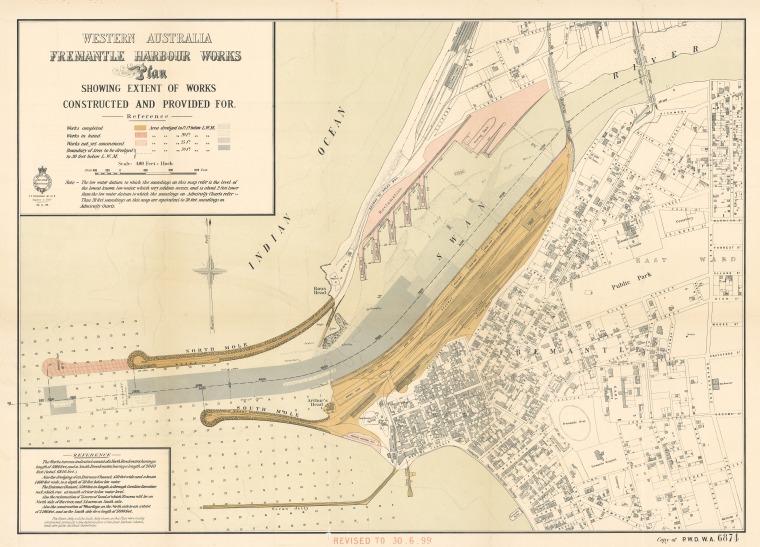
On the north side, a wharf 1000ft long was constructed for the exclusive purpose of unloading coal (to service the increasing number of steam vessels) and railway material. An early plan provided for seven piers and a graving dock at the eastern end of the basin (Figure 11). P&O would use one of the piers for its steamers and convey passengers to Fremantle town by ferry across the harbour. However, by 1904 only one pier had been constructed.

Figure 11 Western Australia Fremantle Harbour Works Plan, 1899 (SLWA)
By the end of 1901, Fremantle Harbour, though incomplete, was fully operational. Thereafter ship-owners could avoid the chaos involved in using the long jetty. P&O had argued in 1898 that the new harbour was not deep enough; two years later it declared that the harbour would become the “new port of call for its mail steamers”. Ormuz was the first of its vessels to enter the harbour in August 1900. 11
When vessels from Europe used the long Cape route, Albany not Fremantle was the logical port of call, especially because it had a safe and commodious harbour. But rapidly-changing technology, the opening of Suez Canal, the discovery and exploitation of gold that enhanced the colony’s financial credibility, and the extension of Western Australia’s railway network with Fremantle as its hub, spelled the end of Albany as the colony’s main receiver of foreign vessels. By 1902, the number of steamships visiting Albany had dropped almost by half to 196, whereas Fremantle, with 349 arrivals, continued its steady dominance. The rapidity with which shipowners used the inner harbour is shown by the statistic that in 1895 there was not a single vacant berth to be had at the long jetty; by 1899 the jetty had been closed.
In 1827 James Stirling argued a successful case for Swan River as the continent’s western headquarters, with Perth as its capital and Fremantle as its port. His proposal, accepted by the Colonial Office, set in motion an array of proposals relating to the port’s creation. For over seventy years dozens were put forward by officials and settlers for facilities to be established either inside the bar that effectively blocked entrance to the river or outside the bar in Gage Roads. However, the colony was too lacking in resources, both human and financial, to adopt any of the proposals. A short jetty, then a long jetty outside the river entrance, were all that the colony could fund, and the latter was far too fragile an arrangement to enhance the safety of vessels that used it; including large foreign vessels (especially steamers). King George Sound was a much safer option.
Fremantle’s acceptance as a safe and viable port for steamships came with the discovery of gold in the mid-1890s which gave the government financial capacity to develop an inner-harbour port. Coode’s plan, Forrest’s support, O’Connor’s skills, combined to create at century’s end inside the river mouth a port which James Stirling believed in 1827 could be done “without difficulty or great expense”.
Annual General Meeting, 2011
Notes
1 Peron, F, A Voyage of Discovery to the Southern Hemisphere, London 1809, Facsimile, Melbourne, 1975, p.141.
2 Appleyard R.T. and Toby Manford, The Beginning. European Discovery and Early Settlement of Swan River Western Australia, UWA Press, 1979, pp. 99-100.
3 ibid., p 50.
4 Darling to Bathurst, 21.4.1827, enclosing Stirling's Report, Swan River Papers. Appleyard and Manford, op. cit., p 53.
5 Appleyard. Reginald. Port of Fremantle, unpublished manuscript, p 23.
6 ibid.
7 My summaries of plans proposed prior to O’Connor have been drawn mainly from Merab Tauman’s biography of C.Y. O'Connor: The Chief, UWA Press, 1978, and the plans themselves are from Daryl V. Fowler, The Port of Fremantle, revised draft of a Master’s degree thesis, 1974.
8 Appleyard, op. cit., p 43.
9 Fowler, Daryl V, op. cit., p 43.
10 Tauman, Merab, op. cit., pp 52-53.
11 ibid., p 85.
This page incorporates material from Garry Gillard's Freotopia website, that he started in 2014 and the contents of which he donated to Wikimedia Australia in 2024. The content was originally created on 7 May, 2018 and hosted at freotopia.org/fhs/fs/7/Appleyard.html (it was last updated on 5 May, 2021). The donated data is also preserved in the Internet Archive's collection.